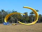
Ipatinga
Appearance
Ipatinga | |
|---|---|
Municipality | |
| The Municipality of Ipatinga | |
 Pedro Linhares Gomes avenue | |
| Nickname(s): "Pouso de Água Limpa" | |
 | |
| Coordinates: 19°30′S 42°32′W / 19.500°S 42.533°W | |
| Country | Brazil |
| Region | Southeast |
| State | Minas Gerais |
| Founded | April 29, 1964 |
| Government | |
| • Mayor | Robson Gomes (PPS) |
| Area | |
| • Total | 165.509 km2 (63.903 sq mi) |
| Population (2009) | |
| • Total | 244.508 |
| • Density | 1.440/km2 (3.73/sq mi) |
| Time zone | UTC-3 |
| Postal Code | 35160-000 |
| HDI (2000) | 0,806 – high |
| Website | http://www.ipatinga.mg.gov.br/ |
Ipatinga is a Brazilian city in the Vale do Aço metropolitan area, state of Minas Gerais. Its population in 2009 was 244.508 inhabitants. Its area is 165.509 square kilometres (63.903 square miles). The city was founded in April 29, 1964.
It's limited with Caratinga, Coronel Fabriciano, Mesquita, Santana do Paraíso and Timóteo.
Images
[change | change source]Other websites
[change | change source]


