Edukira joan

Fitxategi:Basin of Mexico 1519 map-fr.svg

Orriaren edukia ez da onartzen beste hizkuntza batzuetan.
Wikipedia, Entziklopedia askea

Bereizmen handikoa (SVG fitxategia, nominaldi 1.412 × 1.883 pixel, fitxategiaren tamaina: 528 KB)

Fitxategi hau Wikimedia Commonsekoa da. Hango deskribapen orriko informazioa behean duzu.
Commons gordailu bat da, lizentzia askea duten multimedia fitxategiena. Lagun dezakezu.

Fitxategi hau Wikimedia Commonsekoa da

Laburpena

Deskribapena
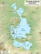
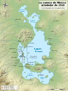
English: Map of the basin of Mexico circa 1519, at the arrival of the Spanish.
Español: Mapa de la cuenca de México acerca 1519, a la llegada de los españoles
Français : Carte du bassin de Mexico vers 1519, à l'arrivée des Espagnols.
Data (UTC)
Jatorria
  • (es) This picture incorporates information from La cuenca de México, special edition of Arqueología Mexicana, july-august 2007, Mexico (in particular, the Enrique Vela's maps of the pages 70 and 60, based on Sanders et al. The Basin of Mexico, 1979).
  • (es) This picture incorporates information from this version of the article Lago de Texcoco on the Spanish Wikipedia.
Egilea
Beste bertsioak

[aldatu]

SVG genesis
InfoField
 
SVG irudi honen iturburu kodea baliozkoa.
 
Fitxategi hau (bektore-irudia) hau Inkscape-ekin sortu da .
 
 This map uses embedded text that can be easily translated using a text editor.
 
  This SVG map uses embedded raster graphics to show its topographic structures.
Kameraren kokapena19° 25′ 09,84″ N, 99° 07′ 59,88″ W Kartographer map based on OpenStreetMap.Irudi hau eta gehiago beraien kokapenekin hurrengo lekuetan: OpenStreetMapinfo


Lizentzia

Nik, lan honen egileak, argitaratzen dut ondorengo lizentzia hauen pean:
GNU head Baimena duzu dokumentu hau kopiatu, banatu edo/eta aldatzeko GNU Free Documentation License baldintzapean, Free Software Foundationek argitaratutako 1.2 edo ondorengo bertsioan; sekzio aldaezinik gabe, azaleko testurik gabe, eta atzeko azaleko testurik gabe. Lizentziaren kopia dago GNU Free Documentation License izenburudun atalean.
w:eu:Creative Commons
eskuduntza berdin partekatu
This file is licensed under the Creative Commons Attribution-Share Alike 4.0 International, 3.0 Unported, 2.5 Generic, 2.0 Generic and 1.0 Generic license.
Askea zara:
  • partekatzeko – lana kopiatzeko, banatzeko eta bidaltzeko
  • birnahasteko – lana moldatzeko
Ondorengo baldintzen pean:
  • eskuduntza – Egiletza behar bezala aitortu behar duzu, lizentzia ikusteko esteka gehitu, eta ea aldaketak egin diren aipatu. Era egokian egin behar duzu hori guztia, baina inola ere ez egileak zure lana edo zure erabilera babesten duela irudikatuz.
  • berdin partekatu – Lan honetan oinarrituta edo aldatuta berria eraikitzen baduzu, emaitza lana hau bezalako lizentzia batekin argitaratu behar duzu.
Nahiago duzun lizentzia erabil dezakezu.

Jatorrizko igoera erregistroa

This image is a derivative work of the following images:

  • File:Lago_de_Texcoco-posclásico.png licensed with PD-self, PD-self/fr
    • 2006-09-19T01:46:06Z Yavidaxiu 1412x1644 (344123 Bytes) {{Information |Description={{es|Mapa de la cuenca de México a la llegada de los españoles}} |Source=Trabajo propio |Date=18 de septiembre de 2006 |Author=Yavidaxiu |Permission={{PD-self}} |other_versions= }} [[Category:Map
  • File:Valley_of_Mexico_c.1519-fr.svg licensed with Cc-by-sa-2.5,2.0,1.0, Cc-by-sa-3.0-migrated, GFDL
    • 2007-09-11T14:00:14Z Historicair 731x849 (270643 Bytes)
    • 2007-09-11T13:51:30Z Historicair 731x849 (272818 Bytes) {{Information |Description={{fr|Les environs de Tenochtitlan vers 1519}} {{en|Valley of Mexico circa 1519}} |Source=Own work |Date=11/09/2007 |Author=~~~~ |Permission={{self2|GFDL|cc-by-sa-2.5,2.0,1.0}} |other_versions= }} {{

Uploaded with derivativeFX

Irudi-oineko testuak

Add a one-line explanation of what this file represents

Fitxategi honetan agertzen diren itemak

honako hau irudikatzen du

31 urtarrila 2010

19°25'9.8"N, 99°7'59.9"W

media type ingelesa

image/svg+xml

checksum ingelesa

e4345d59d5c8f52cd5bbdafd7f052cc8494d3c65

data size ingelesa

540.294 Byte

1.883 pixel

1.412 pixel

Fitxategiaren historia

Data/orduan klik egin fitxategiak orduan zuen itxura ikusteko.

Data/OrduaIruditxoaNeurriakErabiltzaileaIruzkina
oraingoa21:29, 28 urtarrila 202121:29, 28 urtarrila 2021 bertsioaren iruditxoa1.412 × 1.883 (528 KB)SémhurHuexotla <=> Coatlinchán
19:21, 17 uztaila 201319:21, 17 uztaila 2013 bertsioaren iruditxoa1.412 × 1.883 (525 KB)CitypeekEnlargement of legenda in upper-right corner.
19:17, 17 uztaila 201319:17, 17 uztaila 2013 bertsioaren iruditxoa1.412 × 1.883 (533 KB)CitypeekCorrected two errors. Valid SVG now.
19:38, 8 otsaila 201019:38, 8 otsaila 2010 bertsioaren iruditxoa1.412 × 1.883 (533 KB)Sémhurun accent en trop
19:27, 8 otsaila 201019:27, 8 otsaila 2010 bertsioaren iruditxoa1.412 × 1.883 (532 KB)Sémhur+ relief and some improvements
10:27, 31 urtarrila 201010:27, 31 urtarrila 2010 bertsioaren iruditxoa1.412 × 1.645 (99 KB)Sémhur== {{int:filedesc}} == {{Information |Description= {{en|Map of the basin of Mexico circa 1519, at the arrival of the Spanish.}} {{es|Mapa de la cuenca de México acerca 1519, a la llegada de los españoles}} {{fr|Carte du bassin de Mexico vers 1519, à l

Hurrengo orrialdeek dute fitxategi honetarako lotura:

Fitxategiaren erabilera orokorra

Hurrengo beste wikiek fitxategi hau darabilte:

Metadatuak