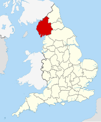
Cumbria is predominantly rural, with an area of 6,769 km2 (2,614 sq mi) and a population of 500,012; this makes it the third-largest ceremonial county in England by area but the eighth-smallest by population. Carlisle is located in the north; the towns of Workington and Whitehaven lie on the west coast, Barrow-in-Furness on the south coast, and Penrith and Kendal in the east of the county. For local government purposes the county comprises two unitary authority areas, Westmorland and Furness and Cumberland. Cumbria was created in 1974 from the historic counties of Cumberland and Westmorland, the Furness area of Lancashire, and a small part of Yorkshire.
Like most fells in the Helvellyn range, Nethermost Pike has grassy western slopes and rocky outcrops on the eastern side. Geologically, Nethermost Pike belongs to the Borrowdale Volcanic Group. Lead was once mined on its eastern slopes, resulting in open workings and underground mines. The eastern slopes are protected as part of a Site of Special Scientific Interest because of the Pike's geological and biological features, which include some of England's best arctic-alpine and tall-herb vegetation. (Full article...)
Image 6'Giants Grave', St. Andrew's churchyard, Penrith, an unusual arrangement of two Viking-age cross-shafts with four hogbacks (in the foreground). In addition, there is a smaller, Viking-age, wheel-headed cross just visible in the background (from History of Cumbria)
Image 17The Eden Valley between Appleby and Penrith, an area referred to affectionately as the heartland of Rheged in the praise poems of Taliesin (from History of Cumbria)
Image 18Greystoke Castle. Held by the Greystoke family, then by the Dacres and inherited by the Howard family during Elizabeth I's reign. Photo:Simon Ledingham (from History of Cumbria)
Image 20Dove Cottage (Town End, Grasmere) – home of William and Dorothy Wordsworth, 1799–1808; home of Thomas De Quincey, 1809–1820 (from History of Cumbria)
Image 21St Laurence's Church, Morland : with "the only tower of Anglo-Saxon character in the NW counties", according to Pevsner. Tower possibly built by order of Siward, Earl of Northumbria, sometime between 1042 and 1055; nave possibly later (1120) (from History of Cumbria)
Image 26Carlisle Castle – begun by William Rufus in 1092; rebuilt in stone under Henry I, 1122–35, and David I of Scotland, 1136–1153 (from History of Cumbria)
Image 38Kentmere Hall, an example of a Cumbrian Pele tower (from History of Cumbria)
Image 39The Staffordshire Moorlands Pan – an enamelled cooking and serving vessel, engraved with the names of four Hadrian's Wall forts sited in Cumbria (2nd century AD). See also the article on the Rudge Cup and Amiens skillet. (from History of Cumbria)
Image 43So-called "Saint's tomb" (left), and "Warrior's tomb" (right), two hogbacks in St. Mary's church, Gosforth. Typically high and narrow Cumbrian style, in the shape of a building with a roof, eaves and walls. The Saint's tomb has a crucifixion on the end, the Warrior's tomb has a procession of armed men (from History of Cumbria)
Image 45The Fish Hotel, Buttermere – where Mary Robinson worked (from History of Cumbria)
Image 46Location of Inglewood Forest, stretching from Carlisle to Penrith; it was the most northerly of the Royal forests (from History of Cumbria)
Image 47The northeastern Irish Sea, showing new settlements with Norse place names. (from History of Cumbria)
Image 48Claife Station on the western shore of Windermere – built in the 1790s with tinted windows angled to take in all the aesthetically pleasing views (from History of Cumbria)
Image 49The Gosforth Cross, 10th-century Viking-age sculpture. (A replica of 1887, with clearer depictions of the decoration, may be found in the churchyard at Aspatria, along with a replica of another cross, the original of which is at Dearham) (from History of Cumbria)
Image 50Roman milestone still in situ by the A66 near Kirkby Thore (from History of Cumbria)
Image 51Wray Castle – built by a Liverpool doctor who had married a rich wife. Constructed in 1840 at the head of Windermere. Associated with two key players of the National Trust : Canon Rawnsley and Beatrix Potter (from History of Cumbria)
Image 52The Ormside bowl, probably late 8th century and made in Northumbria; possibly looted from York by a Viking warrior and buried with him at Great Ormside (from History of Cumbria)
Image 54Swarthy Hill, near Crosscanonby on the Solway coast – possible site of Iron Age hillfort, later the site of mile-fortlet 21 in Roman times (from History of Cumbria)
Image 56Loki stone, Kirkby Stephen parish church, part of a 10th-century Viking-age cross-shaft. But does it show Loki or Satan? (from History of Cumbria)
Image 70The University of Cumbria's Fusehill Campus in Carlisle (from Cumbria)
Image 71This map of cities and towns of Northern England shows the relative lack of urbanisation in Cumbria (shown here as the historic counties of Cumberland and Westmorland) compared to the rest of the region (from Cumbria)
Image 73The Stanegate line is marked in red, to the south of the later Hadrian's Wall. (n.b. Brocavum is Brougham, not Kirkby Thore as given in the map) (from History of Cumbria)
Image 75Approximate extent of Domesday coverage : the district of Hougun, if indeed it was a district, may have covered the three peninsulas at the left of the pink area (from History of Cumbria)
Image 79Brantwood, overlooking Coniston Water, viewed from the steam yacht 'Gondola' – note the angled, corner windows designed to take in the views (from History of Cumbria)
Image 80St Mary's Church, Abbeytown : all that is left of Holmcultram Abbey, founded by David I, King of Scots, and his son, Earl Henry, in 1150 (from History of Cumbria)
The area is important for its wide variety of upland habitats, especially blanket bog, sub-montane and montane heath, montane bryophyte heath, limestonegrassland and flushes, and for the fauna and flora that they support. The site also includes a number of localities of geological interest. (Full article...)
A panoramic view of the ascent of Helvellyn with Striding Edge on the left, then a steep scramble to the summit followed by a scrambling descent via Swirrel Edge on the right, leading to Catstye Cam.
A panoramic view of the ascent of Helvellyn with Striding Edge on the left, then a steep scramble to the summit followed by a scrambling descent via Swirrel Edge on the right, leading to Catstye Cam.