From Simple English Wikipedia, the free encyclopedia
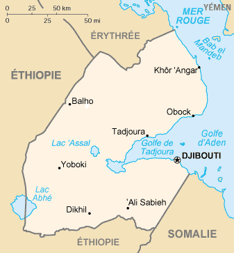
The city of Djibouti is the capital and largest city of the Republic of Djibouti. It lies on a peninsula between the Gulf of Aden and the Gulf of Tadjoura. Djibouti is home to about 400,000 people.
Features of Djibouti include beaches, a large Central Market, the national stadium Stade du Ville, the Presidential Palace and Hamouli Mosque. The Djibouti-Addis Ababa Railway runs from the city to Addis Ababa. Djubouti is also home to the Djibouti-Ambouli International Airport.
Djibouti was founded as a seaport in 1888. The city became the capital of French Somaliland in 1891. It replaced Tadjourah as the capital.
 The peninsula of Djibouti
The peninsula was chosen because it is a natural port. It was attacked during WW2 by the Italians and later by the British.
|
|---|
Abidjan, Ivory Coast · Abuja, Nigeria · Accra, Ghana · Addis Ababa, Ethiopia · Algiers, Algeria · Antananarivo, Madagascar · Asmara, Eritrea · Bamako, Mali · Bangui, Central African Republic · Banjul, Gambia · Bissau, Guinea-Bissau · Bloemfontein (One of 3), South Africa · Brazzaville, Congo Republic · Bujumbura, Burundi · Cairo, Egypt · Cape Town (One of 3), South Africa · Conakry, Guinea · Dakar, Senegal · Djibouti, Djibouti · Dodoma, Tanzania · Freetown, Sierra Leone · Gaborone, Botswana · Gitega, Burundi · Harare, Zimbabwe · Jamestown, Saint Helena · Kampala, Uganda · Khartoum, Sudan · Kigali, Rwanda · Kinshasa, Congo Democratic Republic · Libreville, Gabon · Lilongwe, Malawi · Lobamba, Swaziland · Lomé, Togo · Luanda, Angola · Lusaka, Zambia · Moroni, Comoros · Malabo, Equatorial Guinea · Maseru, Lesotho · Mamoudzou, Mayotte · Maputo, Mozambique · Mogadishu, Somalia · Mbabane, Swaziland · Monrovia, Liberia · Nouakchott, Mauritania · Niamey, Niger · N'Djamena, Chad · Nairobi, Kenya · Ouagadougou, Burkina Faso · Port Louis, Mauritius · Porto-Novo, Benin · Praia, Cape Verde · Pretoria (One of 3), South Africa · Rabat, Morocco · Saint-Denis, Réunion · São Tomé, São Tomé and Príncipe · Tripoli, Libya · Tunis, Tunisia · Victoria, Seychelles · Windhoek, Namibia · Yaoundé, Cameroon · Yamoussoukro, Ivory Coast |


